
20.5km
Paleochora
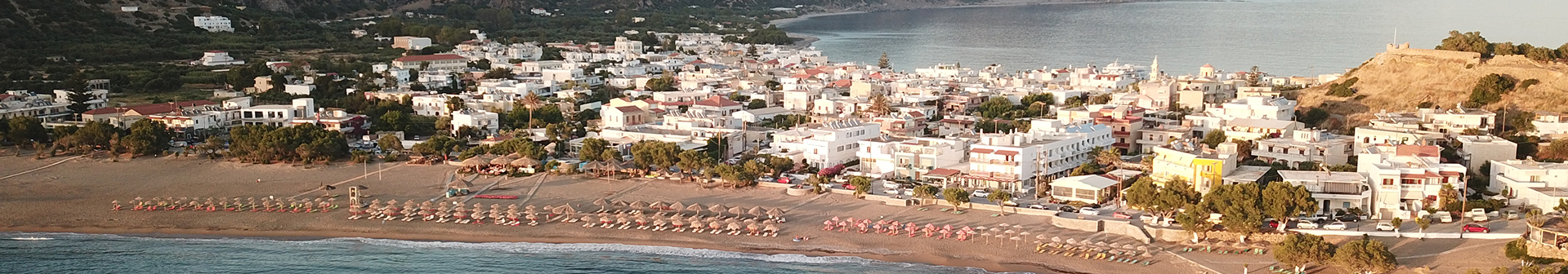
PALEOCHORA
Paleochora is built on a small peninsula between two bays on the Libyan Sea. In ancient times, this peninsula didn’t exist — the hill where the Venetian fortress now stands was once a small island. A powerful earthquake caused the sea floor to rise, forming the current peninsula. On its eastern coast, there is a pier for docking ships, while in the western bay there is an artificial harbor. At the tip of the peninsula, on the islet of Schistonisi, there is a functioning lighthouse.
On both sides of the peninsula are beaches: to the east, a pebbled beach called Chalikia (or Votsala), and to the west, a sandy beach named Pachia Ammos, which is approximately one kilometer long. Four kilometers east of Paleochora, near Gialiskari, there are three more beaches, close to the gorge that begins at the village of Anydroi. Scattered across these beaches are large rocks known as Talos, named after the mythical guardian of Crete.
To the west, you’ll find the beaches of Psilos Volakas, Plakaki, and Karavopetra, while near Grammeno, a small peninsula four kilometers east of Paleochora, there are several more beaches. Ten kilometers west lies Krios beach, and even further, about 18 km away, is the famous Elafonissi beach.
North of Paleochora are hills and mountainous terrain rising up to 300 meters, which slope down to a small coastal plain known as the Plain of Paleochora.
Climate
Paleochora has a very mild and warm Mediterranean climate, according to data from the National Observatory of Athens. During the 9-year period from October 2006 to December 2014, the town recorded an average annual temperature of 20.7°C, making it the warmest location in Greece among all the Observatory’s weather stations during that time. The highest recorded temperature was 45.0°C in June 2007, while the lowest was +1.2°C in February 2008. Notably, on June 27, 2007, Paleochora recorded an exceptionally high minimum night temperature of 35.8°C.
History
In ancient times, Kalamyde, a little-known city, stood north of modern Paleochora. It was likely a port for the ancient city of Kandanos. Due to the area’s strategic importance, the Venetians and General Marino Gradenigo built a fortress there in 1282, naming it Castello Selino, a reference to a former name of the region (possibly linked to wild celery – “selino” – that grew locally).
The fortress gave its name to the wider region, now known as Selino. It was destroyed in 1332 during a revolt against the Venetians, led by Vardas Kallergis and his men, but was rebuilt in 1334. In 1536, it was destroyed again by Hayreddin Barbarossa, the Ottoman admiral. The fortress was rebuilt once more in 1595.
In 1653, the Ottomans took the fortress, made modifications, and established a settlement inside. However, due to repeated conflict and destruction, they eventually abandoned the area. When British traveler Robert Pashley visited in 1834, he found only ruins. Before 1866, the area was only used for temporary shelters by farmers, for storage and stabling animals. The town was later reinhabited by olive oil merchants, as Paleochora served as a port for exporting oil from the Kandanos region — easier to access than Chania. It was officially recorded as a settlement in the 1881 census. In 1897, during the Cretan Revolt (1895–1898), Turkish forces massacred the Christians in Paleochora, then fled to the fortress and eventually left via ships of the Great Powers. After Crete united with Greece, the port of Paleochora flourished due to regular sea routes to Piraeus. In 1941, during the German occupation, the Nazis captured and imprisoned locals suspected of resistance, executing 29 of them. After WWII, Paleochora began developing into a tourist destination — one of the most important in southern Crete alongside Ierapetra — thanks to its climate, beaches, and historical monuments.
Besides tourism, the local economy relies heavily on agriculture and fishing.
For more information, you can visit: www.palaiochora.com